


History of Clarkston, Stamperland & Netherlee
Read on to discover the origins of Clarkston, Stamperland & Netherlee
Clarkston, Stamperland and Netherlee today form pleasant, leafy, residential areas but this belies a hidden past of prehistoric people, private estates, agriculture and early industrial development. Read on to find out more.
Early History
We have evidence of very early settlement in the Clarkston area. About 200 years ago, remains of an ancient village were found in Overlee Park. There were 42 small stone houses, which were at least 2000 years old. They also found ‘querns’ hand mills for grinding corn. Unfortunately, at at the time, no importance was given to this discovery and the remains were destroyed. It would have been a very significant historical site if it had been preserved.
Further findings include a bronze axe, discovered in Busby Glen, a flint tool in a garden in Netherview Road and a flint arrowhead in Woodburn Avenue near Carolside Primary school.
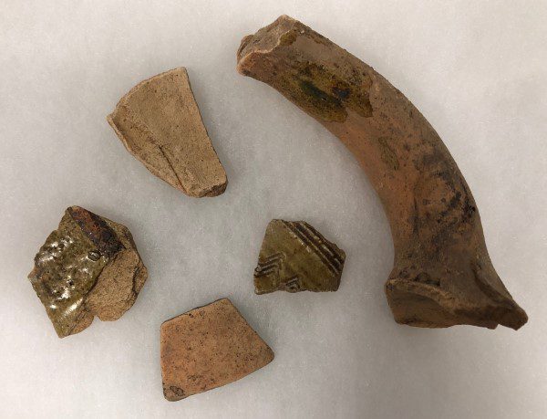
There is also evidence of a very early castle in the area which may have been on the small hill (possibly a motte) next to the shops on Clarkston Road (Beechgrove Park). The photo (below) shows pottery found under a toppled tree at the brow of this hill in 1984.
The areas of Clarkston, Stamperland and Netherlee have a shared history and were at one time known collectively as Lee. We first hear of this name in 1413, but shortly afterwards, the area was divided into three:
Cochrane’s Lee: which was also called North Overlee. It included most of modern Netherlee as far south as Williamwood House and also included the village of Netherlee. It was named after the Cochrane family who owned it until it they ran into financial difficulty. Eventually it passed into the hands of the Earls of Eglinton and remained so until 1668.
Maidlee/Mydlee: which included The Oval, Stamperland Hill and Hillview Drive as well as the area around the centre of modern Clarkston, and which extended northwards over Williamwood Golf course. It belonged to the Lekprevicks of East Kilbride until 1505 when it was sold to the Vicar of Erskine, Archiebald Crawford. In this charter it was defined as consisting of Sluthmanhill, Stawpartislandis, Murehous and Dedecarlside.
Cunningham’s Lee which included Overlee playing fields, and the hill beyond the railway in the vicinity of Victoria Crescent. It was sold again in 1509 to Robert Cunningham. Cunningham’s Lee at this time is a bit of a mystery. (1)
We don’t know where the name Stamperland comes from. The spelling has changed many times over the years and the name was often preceded by the word ‘mid’. Nearby we have Slaymanshill and Dedecarlside perhaps references to an ancient battle.
Williamwood Estate
In the late 17th century, Midlee was acquired by James Maxwell who combined it with other lands including Netherlee and Bogton to form the Williamwood Estate.
James Maxwell was a staunch supporter of the convenanters. In 1678 he allowed a conventicle on his property. It was broken up by government troops and he was forfeited and sentenced to death. The sentence was never carried out and the family were restored in 1688. The participants who were captured were actually supposed to be shipped from Leith to Gravesend to be sold as plantation labourers in the West Indies. By a happy twist of fate, they were freed when the slave-trader didn’t turn up to meet the captain of the Leith ship as arranged.
By the 18th century the Maxwells were keen to improve their estate and it became divided up into larger, single tenant farmsteads as follows: Stamperland, Slamanshill, Overlee, Drumby, Muirhouse, Netherlee and Carolside.
The original house for Williamwood Estate was deserted in 1725, when the Maxwells obtained the lands of Cathcart and took up residence in Cathcart Castle. By the late 18th century a second house had been built, it was further North West but by the late 19th century it was back on the old site. The present Williamwood House wasn’t built until 1930 when George Urie Scott, a cinema proprietor had it designed by the Glasgow architect Charles McNair.
Greenbank Estate
Another large portion of modern day Clarkston came under the Greenbank Estate, which by the 18th century consisted of 250 acres with a beautiful Georgian mansionhouse, Greenbank House, at its centre. The house was built in 1763 for Robert Allason, a successful Glasgow based merchant, who having made money in trade wanted to use some of it to built a landed estate.
Robert had originally come from the area and, after gaining commercial success, must have wished to return to his roots and enjoy his wealth. He managed to purchase and consolidate much of the farming settlement of Flenders and create his estate of Greenbank.
Unfortunately like many entrepreneurs of the time, Robert fell into financial difficulty and had to forfeit the estate in 1782.
The house’s last owners, Mr & Mrs Blythe presented the estate to the National Trust for Scotland in 1976 and the gardens remain a beautiful place to visit today.
The Industrial Revolution
In the 18th century, the industrial revolution took hold all over East Renfrewshire. The area was particularly suited to the textile industry due to the abundant supply of water from its rivers, such as the White Cart and the Levern. Whereas previously, wealth had come from owning land, it now came from industrial undertakings and the old landowning classes saw their own fortunes wane whilst those of the merchants and industrialists rose.
In Stamperland there was one attempt to introduce the textile industry. The low lying ground around Alyth Crescent was advertised as a bleachfield but wasn’t taken on by anyone. Meanwhile, just down the road Netherlee became an industrial village.
By 1792, a paper mill had been established at Netherlee. It was a small concern employing about eight people. It consisted of 9 acres containing a dam and a mill lade. It also had a strip of land attached to a house and stables. The dam was on the west bank of the river slightly upstream from the present weir and there was a large storage pond below the end of First Avenue which is now a filled-in oval terrace.
In 1808 a new owner Archibald McGowan expanded the business for the next 30 years or so. Eventually the mill closed against competition from two paper mills in Cathcart.
It was then transformed into a printfield and altogether there were three printfield ventures at this site; the third and the biggest employing 400 people in the 1860s. By 1871 the population of Netherlee sat at 230 people. Many lived in the row of cottages along what is now the boundary wall of Linn Park. By the 1880s the printfield was out of business and its building fell into ruin. There was a laundry which continued on the site, and then the area was used as a nursery until the area was levelled by bulldozers in the 1960s.

In Drumby, cement, limestone and fireclay were worked on a large scale and there was the ‘Birkenshaw Brick and Tile works’ owned by Mr. and Mrs. Yuile on the site of Williamwood High School playing fields.
The Yuiles built the original Redhurst House on the site of the present hotel. It was unusual as it was made of shiny bricks and tiles. The works declined in at the end of the 19th century and Redhurst house was demolished in the 1950s.
Meanwhile, the industry taking place at Netherlee, Busby and Drumby had led to the growth of Clarkston. Clarkston at this time was on a slightly different site. It was behind its present position, where the station and car park now sit but the original village was mostly demolished in 1866 to allow for the construction of the railway. Because of this disruption, Clarkston foundered for a while before it could re-develop. To fill the void, Sheddens began to grow. The land at Sheddens was part of Overlee, owned by the Watson family. Noting the demand for land for building, they began to feu some of the area, starting with the land where the Buck’s Head would eventually stand.

Clarkston Toll was part of an important trade route between Glasgow and Kilmarnock dating back to the 13th century. In the second half of the 19th century life and habitation centred round Clarkston Toll and the area seems to have derived its name from Mr. John Clark, Toll Keeper, when the house was built around 1860. The Toll House was demolished in the 1960s.
By 1851 its population had swelled to 250. Most of them were engaged in the cotton mills, the printfields or the tile works.
The Twentieth Century
Clarkston however, strengthened by the railway started to catch up again and by the turn of the century had engulfed Sheddons.
In the 20th century, a common theme across east Renfrewshire, was the change of land use from industrial and agricultural to residential. In the 19th century, wealth had moved from the hands of the landowner into the hands of industrialists and merchants. They began to look for areas outwith the smoke and smog of Glasgow, where they could use their fortunes to built grand mansion houses in which to bring up their families. For example, the Williamwood estate had been sold by the Maxwells in 1812 and by 1817 was in the hands of a Glasgow merchant James Stewart. East Renfrewshire appealed because it was seen as somewhere close to the countryside with clean fresh air.
By the 20th century it was not just the wealthy who wanted to live here. Due to the improvements in transport and communications it became easier for people from all walks of life to look for homes in areas away from the city centres.
By 1900 Clarkston had grown to include Springhill Road, Summerhill Road, and some of Victoria Crescent and Viaduct Road.
After 1900, came Carolside Gardens and Avenue and the terrace from Strawhill Road to the station. Malborough Gardens was also built at this time as well as the first houses appearing on what would be Benview Road, Stewart Drive and Sunnyside Drive.
The real building boom came in the 20s and 30s. Until then, Stamperland and Netherlee had remained as farm land but in the 1920s, the last Stewart died and the land was acquired by two local men: Andrew Mitchell, a builder and Robert Paterson, the Camp Coffee manufacturer. The two men had plans to develop the whole area, even the golf course, although the club fought off their plans. However, red sandstone terraces began to appear up Clarkston Road from Netherlee to the Toll.
In the 1930s, 8000 private houses were built in Clarkston by Mactaggart & Mickel. Carolside Park was one of the first of the 1930s developments. These were unit homes, constructed so they could be made to consist of 3, 4 or 5 apartments as the owner wished. They were comprised of two large rooms – one on each floor, with alcoves that could be divided off by curtains or a partition. A unique marketing strategy was to build a demonstration house in central station to entice commuters to buy.
Mactaggart & Mickel also built Netherlee Park on the land which had been Netherlee Farm. The development was made up of 4 different styles of bungalows and they were marketed as ‘the house that the housewife built’ (2)

However, other builders were busy too, for example James Wright of Cathcart, who built bungalows and semi-bungalows which could be obtained with a mortgage of less than £1 per week. Also prolific was John Lawrence, who constructed the Stamperland terraced and semi-detached two bedroom houses.
With the building of houses comes the need for more amenieties, not least schools for families moving into the area. The first school in the Clarkston was a private preparatory school called the Arundel School, established at the end of WW1 in the home of Miss Hilda W Cumming in Overlee Road. In 1924 the school moved to a building made of corrugated iron on Busby Road and became known as the Tin Academy. The building was demolished after WW2 to make way for the police station.
In 1929 the Radleigh School was opened up by Miss Price in what was the old Williamwood Golf Club. The long time teacher was Miss Jessie Walker. When she retired in 1963, the parents formed a company and bought the school and it stayed open until 1973.
The first public school in the area was Netherlee. It opened in 1933 but was too small as it had been planned before all the new building in Stamperland so almost immediately, in 1936, a large annexe was added.
Today, the area around Clarkston and Netherlee is a desirable, residential suburb with good schools and amenities attracting a steady stream of new residents.
References
(1) Welsh, Thomas C., Eastwood District History and Heritage, Eastwood District Libraries 1989, p.56
(2) Glendinning, M (ed), Home Builders: Mactaggart & Mickel and the Scottish housebuilding industry, Edinburgh, RCAHMS, 1999, p64
Further Reading
Crossroads Community: A History of Clarkston, Eastwood District Libraries, 1988
Nisbet, Stuart, Stamperland, Stamperland Residents Association, 1999
Welsh, Thomas C., Eastwood District History and Heritage, Eastwood District Libraries 1989